
FSC® GIS Portal
A cutting-edge tool for FSC audits
FSC has developed the GIS Portal - a geospatial web app – which allows FSC forest management auditors to access geospatial information in combination with up-to-date satellite imagery.
The portal enables forest management audits to be more efficient; aiding auditors to carry out a more objective selection of areas for onsite inspections, and enabling part of the forest evaluation to be performed remotely. Through the GIS Portal, auditors can visualize the boundaries of the specific audit area and if not provided, these can be directly drawn on the map.
Using date specific satellite imagery, auditors can then, for instance, perform change analyses in the audit area to identify areas with loss or gain in vegetation - see an example in the image below.
Analysis can also be performed against specific FSC Principles and Criteria, enabling forest management auditors to identify changes related to that criterion which will be highlighted on the map. For the analysis, different geospatial datasets can be overlaid on the map such as: tree cover loss, protected areas, indigenous and community lands and water courses. All results can be then exported as a pdf file.
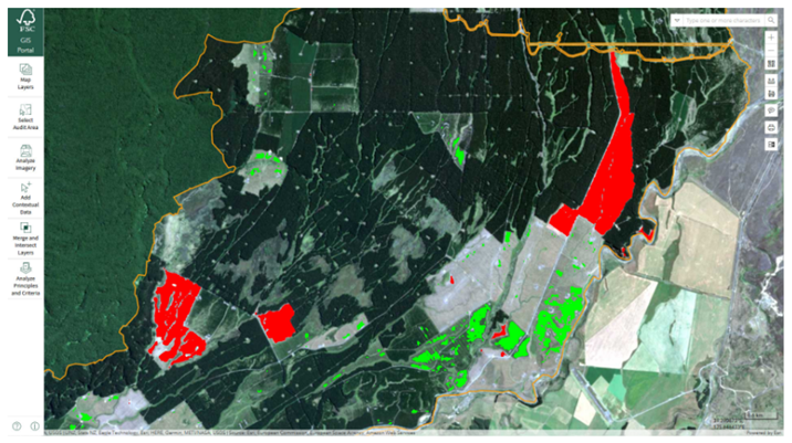
FSC GIS Portal image showing detected change across the forest area. Red means loss, and green means regeneration of forest areas.
How can Certificate Holders contribute to FSC GIS Portal?
Certificate holders can provide (on an entirely voluntarily basis) the boundaries of their certified forests through the FSC GIS map, here. These boundaries will be then made available also on the FSC GIS Portal for auditors to consult. Contributing to the FSC GIS map initiative, not only increases the transparency of the FSC system, but also allows forest owners to show where their forests are and promote their operations while making it possible for stakeholders, researchers, and consumers around the globe to access this information. More information on the FSC GIS map and how to contribute to it, can be found here.
To find out more about the GIS portal and how to use it, see the FSC website. Forest management auditors can request the access to the portal contacting maps@fsc.org.
Sign up to our newsletter to receive the latest updates from Soil Association Certification Forestry.